Monday, March 26, 2012

TULE ELK STATE NATURAL RESERVE: Trip #30 of 70

It was a challenge putting together the itinerary for my visits to all of the southern California Parks on the closure list. Many of them have limited hours, and a few of them are geographically isolated. Tule Elk State Natural Reserve in Button-willow (near Bakersfield) was open daily when I first planned my road trip. But, when the time came, they too had restricted their hours to weekends only, and I had to scramble to fit in this park.

I would have been dis-appointed if I had made a special trip at a later date. Although I milked my visit, I still found myself pulling out of the parking lot after forty-five minutes. January is not a good month to view Elk. They are not active in winter and were not in sight.

Thus, the photos of these Elk were taken last summer at another State Reserve just south of Crescent City - in August - at the height of the rutting season when Elk are most active. In all probability, the Elk in my photos were once part of the Buttonwillow herd, as I will explain below.

In its original pristine distribution, it is estimated that half a million animals roamed the regions up and down the state. The grandness of the scene has been likened to what is seen in the Serengeti. Click here to view maps showing the dramatic, rapid decline of California's Elk population.

Serious commercial exploitation of Tule Elk began during the early 1800s, when they became part of the hide and tallow trade. Never-theless, they were still plentiful until the gold rush brought thousands of new immigrants to California. The demand for meat increased greatly. By1850 the entire Sacramento Valley Tule Elk population had been wiped out. In the San Joaquin Valley, where hunting was less common, the Elk survived somewhat longer. However, in 1863 market hunters claimed to have killed the last Elk cow and calf left in the tules of the San Joaquin Delta.

A small parking lot, a couple of picnic tables, a viewing stand and some educa-tional Elk information on the bathroom walls is pretty much the essence of this state park.

A Visitor Center door was not only closed, it was bolted shut. A couple of State vehicles sat outside a small residence. Hoping to get the attention of the park workers so that I could talk with them and pay the day use fee, I let Roxy off her leash and let her run around the picnic tables. But on this day, neither Elk nor Human was to greet us at this state park.

A fifty year effort to save the nearly extinct Tule Elk begain in 1874 by Cattleman Henry Miller. In 1932, the herd was given permanent protection on the park property. Elk from this reserve have been successfully transplanted to other areas in California where free-roaming herds of Tule Elk can be found today - including the ones in my photos taken 500 miles north! So, even if the reserve closes to the public as scheduled on July 1, it still remains a state park, and a protected habitat for these gorgeous animals.

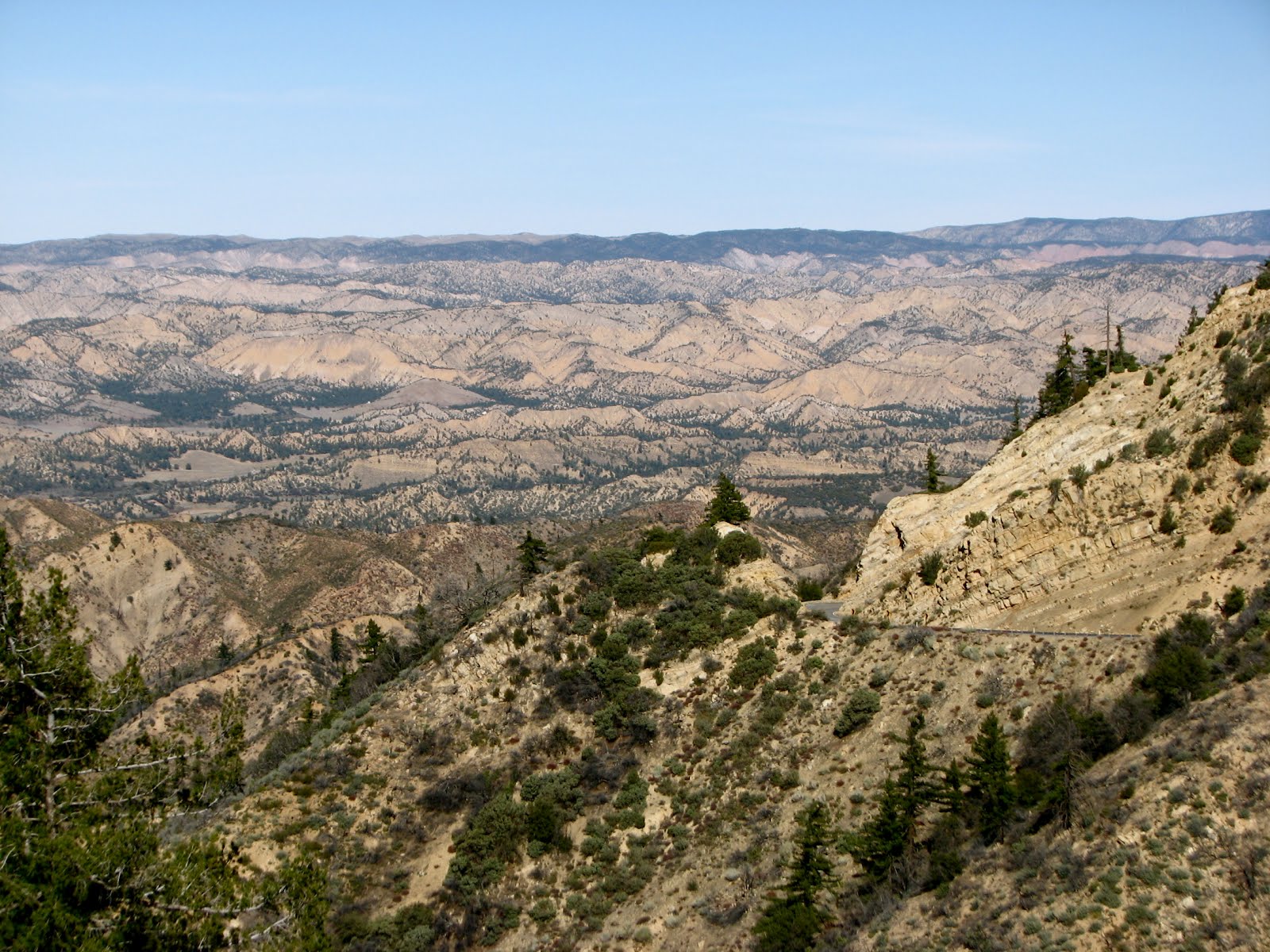
After reading ever word of information available, Roxy and I hopped back into the car and drove to nearby Interstate 5 for a fast ride home. Earlier in the day, in the spirit of exploring California, I opted for a 70 mile scenic drive via Highway 33 from Ojai to Ventucopa through the Los Padres National Forest.

It is a windy road, with dramatic changes around every bend. Even as a driver I am occasionally prone to car sickness. I found that frequent photo stops was the perfect solution to that problem, and was stunned by the beauty of the drive. On this blue-sky Saturday, I shared the road primarily with shirt-sleeved bikers and jeepers with their tops down.

I don't know if I will make it back to Tule Elk SRA for the mating season. Even if it is fortunate enough to remain open, Bakersfield in August is not a prime destination. I'm glad it will be there for the Elk though.

I hope to see you at the State Parks.

Lucy

Saturday, March 24, 2012

LOS ENCINOS STATE HISTORIC PARK: Trip #29 of 70

Although mid October, it was a beautiful, sunny mid 80s afternoon at Los Encinos State Historic Park , a welcome break from LA's unseasonable triple digit heat of the past two days.

The good news: Los Encinos has been given a one year reprieve from closure thanks to a $150,000 anonymous gift by a local resident who wants the park to remain open.

Located in the San Fernando Valley town of Encino, it is ten miles north of Hollywood, surrounded by freeways and busy streets. The park is in the middle of a "regular" residential neighborhood, so it is easy to convince yourself you've taken a wrong turn. Parking is on the street, and free.

Roxy and I got out of the car, passed a cactus garden and found my friends Rosey, Ernie and Jeff already kicking back on a blanket on the lawn, enjoying a tin a gourmet popcorn and the light after-noon breeze.

The land that Los Encinos SHP occupies has changed ownership numerous times through the centuries. The original 4,460 acres was under the control of Mission San Fernando Rey founded in 1797. When Mexico won independence from Spain, they secularized the Mission lands. In 1845 Mexican California governor Pio Pico granted Los Encinos to three Indians, Ramon, Francisco & Roque, who then sold it to Don Vicente de la Ossa.

This single story, eight room adobe built by de la Ossa in 1849 became a favorite stopping place for the numerous travelers on El Camino Real. A two story out building was later added to house ranch hands.

A natural spring pumps warm, soft water into a pond inhabited by geese and ducks. For twenty-five cents a dispenser delivers food for the water fowl. We fed it our quarters until it was empty, giv-ing a few of the feed bags to some coinless children. Occasional and slightly painful games of "tug-of-war" occurred when aggressive ganders, annoyed that we had run out of food, latched onto our thumbs with their powerful beaks. The ranger promptly refilled the bird's vending machine.

In 1869 Eugene and Phillipe Garnier acquired the property. Eugene built the two-story limestone farmhouse similar to their home in the French Basque Country, as well as the brick-lined pond shaped like a Spanish guitar.

An old sheep shed and pen still stand. The gold rush, Civil War and drought combined to boost sheep production in California. Sheep withstood drought better than cattle. In 1876 sheep populaton peeked at seven million yielding a “wool clip” of 57 million pounds. Sheep graz-ing gave way to grain cultivation in the 1880s & 90s. And like so much of southern California, only a small citrus grove remains where once there were acres of orchards.


The tour through the eight room adobe is filled with furnishings, artifacts and a detailed history of the various owners. You are only allowed inside the rooms with a guided tour, and when I was visiting, there was only one tour on Saturday.

The Garniers were famous for their hospitality and delicacies of their table. Hand selected wines, imported cheeses and freshly prepared olives from their ranch made dining at Garnier Salon a splendid event. After their meal, a game of cards,
fine liqueur and a good cigar provided guests - including regular patron General Pio Pico - and host with an evening to remember.

The Northridge Earthquake of 1994 cracked open the adobe walls. Plaster fell everywhere, revealing multiple colors of the decorative wall finish that had been hidden for decades in the Garnier Salon.

Unfortunately it also caused the end of the adobe to crash outward. The softer adobe wall battered against the more rigid fireplace, adding to the collapse of the gabled end wall. The reconstruction contains much of the original adobe. A reinforced concrete bond beam ties the top of the walls together to provide additional safety during future earthquakes.

When Garnier got in over his head financially, the wealthy Gaston Oxarart foreclosed on him, continuing the string of rancho owners with roots in the French Basque Pyrenees. Oxarart owned the ornate hand tooled leather saddle, and provided his loved ones with luxuries.


In the 1940s, local resident Marie Stewart spent years leading the struggle to save the de la Ossa Adobe. Her efforts fended off its demolitation and lead to the establishment of Los Encinos State Historic Park. She gathered personal belongings from the descendants of Rancho El Encino families, including the saddle and wedding dress. Thanks to her efforts, and to the recent anonymous donor, you can still visit this lovely park for another year, with the hope that an additional twelve months will find another solution to closure.

My friends and I lingered through the late afternoon, taking one last stroll around the grounds before heading to our various homes in the lower half of the state. Roxy cut loose for a few moments in the enclosed livestock pen, herding the ghosts of sheep long past and relishing a roll in the grass.

I hope to see you at the State Parks.

Lucy

Sunday, March 18, 2012

ZMUDOWSKI STATE BEACH: Trip #28 of 70

Zmudowski State Beach is the second of two beaches slated for closure in the small, central coast town of Moss Landing. (The other is Moss Landing State Beach which I had the pleasure of visiting earlier in the day.)

As the gull flies, the two beaches are connected. A moderately ambitious hiker could walk from one to the other.

But, it is at this point in the journey that California Highway 1 veers away from the coast. So, for those of us without wings, it is a ten mile drive between the two beaches, through the surrounding agricultural lands where there are Strawberry Fields Forever.

The road narrowed and was full of muddy potholes. Is this a state maintained road? A "private property" sign placed at a forty-five degree angle made it unclear which road was public and which was private. I actually had the car turned around, thinking I must be headed in the wrong direction. Yet, I knew I'd followed the signs correctly so I did another 180 and forged ahead.

After passing some marshy farmlands and navigating a few more road obstacles, I suddenly found myself at the official beach gate. The dunes were straight ahead, including Zmudowski's sandy, miniature tetons.


A sign stated that consuming alcohol was prohibited within twenty-five feet of the parking lot. I have a life long tendency of taking things like this too literally.

It has both gotten me into trouble and been a substantial source of personal amusement over the years.

Sooo... I took about a dozen steps up the first sand dune, knowing my stride was at least two feet per step, and took a photo of how far I would have to walk in order to legally have a drink. Silly, I know. It was all academic of course, as I had no alcohol either on my person or in my car.

This vantage point however, provided lovely views of the farmlands to the North, and the town of Moss Landing to the South, including the PG&E towers.


Finally I climbed over the sand dunes in earnest, enjoying the beautiful plant life and, of course, the ocean. Sunsets at the beach often border on a theatrical experience!

I plopped down onto the sand and sat for awhile doing one of my favorite beach activities, absolutely nothing. I listened to the sound of the waves, as the afternoon winds blew through my ears and cleared my cranial gray matter. And I wondered...

... Why are two beaches in one town - Moss Landing - being closed? Can't Moss Landing keep at least one beach? On the drive between Monterey and Santa Cruz on Highway 1, there are state beaches every few miles. I have to guess that Zmudowski State Beach is not well attended. No doubt the poor roads contribute to it's lack of tourists.

I'm glad I took the time to visit. Spring break is coming up. I hope folks will take a day, choose a state park near you, and get out with your family to enjoy our beautiful state and/or learn her history.

I hope to see you at the state parks.

Lucy

Tuesday, March 13, 2012

MOSS LANDING STATE BEACH: Trip # 27 of 70

The sand dunes at Moss Landing State Beach are immediately west of the small parking lot. On the east side, just inches away from your front bumper, are small cliffs leading down to Elkhorn Slough, the famous National Estuarine Research Reserve. Elkhorn Slough flows into the ocean here at Moss Landing. So closely are the beach and the slough entwined, that when I first heard Moss Landing Beach was closing, my immediate thought was, "Oh no! I haven't kayaked on Elkhorn yet to see the birds, otters, sea lions and other marine critters that populate the estuary.

Although geographically only footsteps apart from each other, from a government standpoint, they are completely different entities. It is the beach that is closing. Kayaking, birding, educational and research activities will continue uninterrupted at Elkhorn Slough.

The beach is located about halfway between Santa Cruz and Monterey on California Highway 1 in the small town of ... Moss Landing! The familiar landmarks include a small harbor, the PG&E power plant stacks, and the bridge that crosses the slough. I wondered what those black things were, floating in the water. Large birds?


Nope! When I got out of my car and looked straight ahead into the slough, I saw a raft of Sea Otters! Otters tend to rest together in single-sex groups called rafts that typically contain 10 to 100 animals. I'd never seen one before and I was thrilled!

I'd estimate there were 30-40 Otters in this particular raft. Wow! I'm going to guess that the Otters in this raft were male, given both their size and the absence of baby Otters who are usually on the scene this time of year.


I could hear the echoey barking of Sea Lions under the bridge. Just below me on the beach, appeared to be a small, young seal resting in the sand.

There were already a few folks on that area of beach, and the seal seemed unperturbed, so I decided to head down with my camera.

Well! It wasn't a Sea Lion at all. It was an Otter. I've never seen an Otter out of the water before and was surprised how large he was. I stood as still as possible. My long lens allowed me to get some shots without making him uncomfort-able.

I always feel honored when any wildlife allows me to approach be it a bird, a bug or a mammal. I thanked him for his time and headed over to the sand dunes.


Moss Landing State Beach is a mile of dune protected beach area. Offshore fishing, surfing, windsurfing and horseback riding are popular activities, although swimmers and surfers need to be aware of strong rip currents. This area is an important stop along the Pacific Flyway so birdwatching is popular.

The beach is a favorite place for picnics because the dunes protect it from afternoon winds. If you walk north a couple of miles you'll end up at Zmudowski State Beach, another park on the closure list.


There are some folks who would say that time stopped in Santa Cruz somehwere in the late 1960s. Back at the parking lot, a custom painted car was evidence of that. I can't say I really mind. In my travels through Monterey County, I was delighted to find the Santa Cruz' college radio station KZSC, playing the "non-hits" from the 60s and 70s without resorting to standard "classic rock" fare. Quicksilver Messenger Service anyone?

I looked back down into the slough and saw that my Otter friend was finally making his back into the water. As he took a prayerful stance I had to wonder if he was praying, "Dear God, please make that woman with the camera go away."


He then flipped onto his back and floated out towards his buddies in the raft.


That's the thing about visiting the State Parks. There are often unexpected delights. There were still a couple of daylight hours left, so I hopped back into the car to head to Zmudowski State Beach down the road, to see what adventure awaited me there.


I hope to see you at the state parks.

Lucy