Tuesday, July 24, 2012

POINT CABRILLO LIGHT STATION STATE HISTORIC PARK: Trip #70 of 70 !!!

Tuh Duh! Drum roll please. Presenting Point Cabrillo Light Station State Historic Park, trip number 70 out of 70 of the State Parks that were put on the closure list a year ago! Woohoo! To be honest, when I began my visits in July 2011, I wasn't even sure if I actually intended to get to them all. But I did! And it has been well worth it!

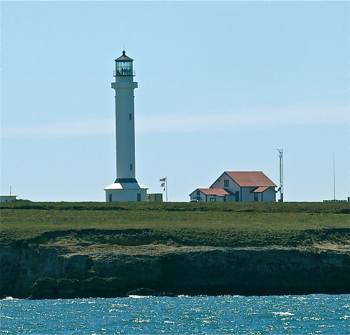
Point Cabrillo Light Station includes the historic 1909 Light Station, and 270 acres of undeveloped coastal bluffs and prairie. The property was purchased and preserved from development in 1992 by the California State Coastal Conservancy and managed by a non-profit affiliate, the North Coast Interpretive Association. It became a state park in 2002.

The park includes not only the light house, but also three restored buildings that were the homes of the light house keepers, a small marine museum, and walking trails that take you through the fields and meadows, and along the spectacular head-lands of Mendocino that thrust out into the Pacific.

Patty and I began our visit by parking in the day-use lot and walking the half mile down the access road. Every few yards was a plaque with a marine science related question, like: "If it takes a Gray Whale two months to travel 6,000 miles from Baja to the Arctic, how many miles per day must it swim?" Word Problems!

But, before our brains hurt too much, we were rescued by the appearance of the light-keepers' homes and out buildings. Photographs and furnishing from the day are inside the three buildings. The exteriors are painted in what we learned were the tradi-tional lighthouse keeper colors, and the gardens filled with all of those lush perennials that refuse to grow at my inland home.

A few more yards down the road is a large shed - The Marine Science Exhibit - a small but packed museum filled with specimens of all sorts. There are a couple of modest aquariums, many shell exhibits, and even a paper mache Gray Whale made by art students from the local Big Brothers and Sisters organization.


The ground floor of the lighthouse is half museum, half gift shop. The stairwell to the top is roped off, for official use only. It is chalk full of the beacon's history, including photographs of lighthouse families from the past.


The emblems of The US Lighthouse Service, The US Life Saving Service and the US Coast Guard were displayed proudly in the museum.

The actual light that cuts through the pea soup fog every ten seconds is itself a classic. It is a Fresnel lens third order rotating optic built by the Chance Brothers of Smethwick England. Most Fresnel lenses were made in France with only about fifteen coming from the British Chance Bros. The Point Cabrillo lens is one of only three remaining in the USA. This four panel lens rotates one complete revolution every forty seconds, thereby producing a "flash" anywhere on the horizon every ten seconds. Gorgeous!

Next we headed out to the cliffs and meadows of the headlands. A Sea Lion was swimming in the cove.


A Deer was munching in the meadow, perhaps on these exotic, two-tone poppies, or the lavender and yellow asters.


Two orange billed Black Oyster Catchers came out to protect their nest from marauding Seagulls. Birds, sea mammals, land mammals, hiking, history, wildflowers and a lighthouse all in one park. Not bad!

When California State Parks acquired Point Cabrillo, the management was assumed by a newly formed non-profit organization: The Point Cabrillo Lightkeepers Association (PCLK).

The State provided the Coastal Conservancy with four million dollars to be used for the restoration of the Light Station. From 2002 to 2006, the Coastal Conservancy granted that money to the PCLK who used it under the supervision of the State Parks Department. Is this getting confusing yet?

The PLCK used the funds to restore two of the three light keepers' houses and the three historic out buildings. They state that further restoration, along with the historic fencing and gardens will be accomplished as additional funds become available.

Funds? What funds? This park is the 70th park that I have visited that is on the closure list due to lack of funds.

Or so we thought. I cannot close out my year long project without mentioning last week's stunning news that California's Parks and Recreation department "discovered" they had under reported 54 Million Dollars $!$! This has resulted in the resignation of parks director Ruth Coleman, and the firing of one other employee. In case you were out hiking and missed the news, you can read about it in this Sacramento Bee article.

I join those who are outraged at the deception, the cover-up, and whatever else will be revealed in upcoming hearings. Each and every park on the closure list was responsible for finding their own funds to stay open. Thousands of people have contributed time and money in big ways to make it happen. To all of you I say, "Thank You!!!"

I do not regret one minute spent at our beautiful parks. I hope this "found" money returns to parks and rec so that we all can continue our ownership of our amazing and diverse lands.

May the brilliant Fresnel at Point Cabrillo Light Station continue to shine and draw us in. And maybe once in awhile, it can beam towards Sacra-mento and shed some light on any nefarious accounting practices.

And now... for the rest of the state!

I hope to see you at the State Parks.

Lucy

This blog is dedicated to the memory of my Father, who loved reading maps, exploring alternate routes, and taking the road less traveled.

Alvin David Dick, April 28, 1926 - May 20, 2012

Monday, July 23, 2012

MANCHESTER STATE BEACH: Trip #69 of 70

This particular blog is more personal than most of my posts. I have debated whe-ther or not to write of my in-ward experiences and obser-vations while at Manchester State Park & Beach, and I have decided to do so.

It was while visiting this park that I received word that my Father had completed his earthly journey and passed away. This was followed by an annular solar eclipse. As my trip to Manchester will be forever colored by these two events, I am choosing to write about them.

A red dragonfly greeted me at the entrance of the beach. In some Native American tradi-tions, Dragonfly represents illusion. Or as the saying goes, "Things are seldom what they seem."

Perhaps that is why I found a pine cone in the sand, and saw birds moving in unison as they fished their dinner out of the surf. Maybe the energy of the day was unusual be-cause before the afternoon was done, we'd be viewing the only annular solar eclipse that we would see in our life time.

When planning our week long Fort Bragg/State Parks trip for the third week in May, Patty and I had originally planned to begin at one of the heavily forested parks. But when we realized the eclipse would be 90% visible from any beach on the northern California coast, we instead opted for Manchester Beach to begin our trip.

The state beach extends five miles from just above the mouth of Garcia Creek to the mouth of Alder Creek. Walk-ing north, we had a pristine beach almost to ourselves, even on a clear Sunday with an upcoming eclipse!

To the south, huge logs that have been tossed up by the sea lie in jumbled piles at the foot of sand dunes. Man-chester is known for the large quantities of driftwood that accumulate on shore. Small structures - both crude and creative - had been assembled on the sand by previous beach goers.

Also near Manchester’s southern boundary is the Point Arena Lighthouse, where visitors can still climb to the top of the Pacific Coast's tallest ocean beacon. Sitting on the rocky cliffs so familiar to California's north coast, it was originally built in 1870, then rebuilt after the 1906 earthquake.

As always, the water birds made me smile as I watched them search for food in the shallow water and sand. But not even they could com-pletely snap me out of my heavy-hearted, anxious mood.

I had spent the last four days with my Dad in the South Bay. He had slipped into a coma three days earlier. I spent time at his bedside singing traditional hymns while he slept. I knew his time was short, a day or two at the most.

A small estuary lay behind the dunes on the south end of the beach, offering resting and nesting habitat for waterfowl.

A driftwood log took on the shape of an Alligator bench. I spotted an odd looking rock. It was different from the other beach rocks. This one was flat and smooth. It had the shape of a man's footprint. I held it for a moment. It made me think of my Dad, and how his "walk" was coming to a close. I wanted to show the rock to Patty, but she was about a half mile down the beach, so I put in on the "alligator bench" where I could find it to show her later.

When Patty caught up with me I picked up the rock to show her. As I held it in my hands it broke into three pieces. I was stunned. I lay the rock down on a piece of wood and we watched as cracks continued to form in the pieces of rock until there were eventually eight or nine broken pieces. It seemed a metaphor for my Dad's body physically breaking apart. I actually found myself checking the time. It was 3:30pm

Wondering if the rock was made of a soft material we threw pieces of it against other rocks and wood, but it would not break into any more pieces.


We quietly began our walk back to the north end of the beach, passing more driftwood. A huge flock of white seagulls - at least 100 birds - flew over my head and the song "Swing Low Sweet Chariot," popped into my mind. It was one the hymns I'd been singing to my Dad. The gulls made me think of the line, "a band of angels comin' after me, comin' for to carry me home." I teared up. I could almost see the gulls pulling the chariot.

Within five minutes my cell phone rang. Dad had passed at 3:45pm. He was home.

We walked quietly along the creek for about an hour. Then we found a bit of shelther from the wind in the dunes, donned our "eclipse sun-glasses" and watched the sun disappear...


...and then return.

The eclipse was the perfect final metaphor that was offered up on this day. My Dad had suffered for years. Now the light had returned. We were both at peace.

I hope to see you at the State Parks.

Lucy


This blog is dedicated to the memory of my Father, who loved reading maps, exploring alternate routes, and taking the road less traveled.

Alvin David Dick, April 28, 1926 - May 20, 2012

Sunday, July 22, 2012

SALTON SEA STATE RECREATION AREA: Trip #68 of 70

First there was a Salton Sea. Then there was no sea. Now there is again.

The Salton Sea State Recre-ation Area just south of Palm Springs is both one of the world's largest inland seas and one of the lowest spots on earth, sitting at 227 feet below sea level.

In this particular incarnation, the Salton was accidentally re-created in 1905 when high spring flooding on the Colo-rado River crashed the canal gates that lead into the Imper-ial Valley. For the next eight-een months the entire volume of the Colorado rushed down-ward into the Salton Trough. By the time engineers were able to stop the water in 1907, the Salton Sea had been re-born at forty-five miles long and twenty miles wide, crea-ting 130 miles of shoreline.

The Salton Sea is one of only two parks of the 70 on the closure list that I had previ-ously visited. I know it's not the favorite park of some folks. In the winter many dead fish wash up on shore attracting a lot of flies. I find in endlessly fascinating though, and was sorry I didn't have more than a few hours to spend to view and understand the sea's oddities.


On some days, up to four million birds – over 400 species - visit the sea at one time. This was of course, a major draw for me.

Not to mention the beautiful, rainbow stripe colors of the marsh foliage and accom-panying sky!

Eons ago, the Gulf of Cali-fornia flowed all the way up here and beyond the Colo-rado River. Eventually, sand deposits formed a dam be-tween here and the ocean. Behind the dam a huge inland sea was created. Over cen-turies, fresh water from the river replaced all of the salt water creating Lake Cahuilla.

About 500 years ago the Colorado River shifted south into the gulf, and the lake began to dry up, exposing large salt deposits.

Native Americans lived along the edges of this lake for generations. Their fish traps and other artifacts from those days can still be seen.

In the mid 1800s, the lake was nearly dry. Miners came for the salt and farmers for the highly fertile soil. Water was brought in via irrigation canals, and agriculture commenced.

Today the sea is once again shrinking and becoming saltier as the fresh water evaporates.

There was a mild sulfur smell in the air on the day I visited. This was caused by large algea blooms in the sea, as a result of fertilizer in the fresh water agricultural run-off. When the algae blooms die en-masse, oxygen levels go down and the sulfuric aroma can be quite potent on some days, I'm told. This, and winter water temperatures below fifty-five degrees are what is believed to cause the massive number of dead fish - mainly Tilapia - on shore every year.

As a recreation area, The Salton Sea saw it's heydey in the 1950s and 60s, with Air-stream trailers galore popu-lating the campgrounds. Var-ner Harbor provides easy access to the sea for boating and water skiing. I personally can't imagine skiing or swim-ming in such heavily salted water. Ick! I was tempted to rent a kayak, but the after-noon winds were already kicking up so I decided against it.

Increasing salinity has not only made swimming a less popular activity here, but has also limited the number of types of fish that can be found. Most fish currently caught are Tilapia (when they're not covering the shoreline with their skeletons.)

In addition to the Tilapia, Striped Bass, Orange Mount Corvina, Gulf Croaker and Sargo are the main species that have been introduced to the Salton, beginning in 1929. Although the sea is consi-dered to be one of the most successful fisheries in the world, the increasing struggle with high salinity levels and unnatural algae blooms make it a less and less healthy environment for the fish.

So the battle is on to save the sea. In some ways though, it's the opposite of Mono Lake. With Mono, it is human interference that has caused the lake levels to drop and the salinity level to rise. Efforts to save Mono Lake primarily involve reversing the human-made damage.

The Salton Sea on the other hand, seems to be once again drying up of its own accord. True the algea blooms are aggravated by runoff from farmlands, but I found myself wondering about the wisdom of trying to save a sea that seems to be disappearing somewhat naturally.

Well, all that being said, I only have a few hours of informa-tion with which to form an opinion. So, I will leave it to those who have more know-ledge and skill in this matter than I do - and to Mother Nature of course - to deter-mine the long term fate of this sea. And where will all the birds go?

I'm anticipating finding myself in this part of the world again next winter. I will most defi-nitely alot a full day to return to this strange body of water, to take memory cards worth of photos of birds and dead fish. Yeah!

I hope to see you at the State Parks.

Lucy

This blog is dedicated to the memory of my Father, who loved reading maps, exploring alternate routes, and taking the road less traveled.

Alvin David Dick, April 28, 1926 - May 20, 2012