Saturday, April 28, 2012

COLUSA-SACRAMENTO RIVER STATE RECREATION AREA: Trip #36 of 70

I will always remember my trip to the Colusa-Sacramento River State Recreation Area as the day my long time travel companion - my Cannon Power Shot 12x zoom camera - bit the dust in the middle of a hike.

As serendipity would have it, I had brought my cheap water-proof camera with me since rain was predicted. As it turns out, this little camera doesn't take bad pictures. Its downfall is a crappy LED display and no view finder. The fact that it was only a 3x zoom didn't really come into play since I couldn't see what I was shooting anyway.

The levee marsh was kind enough to offer up a comfty, over-stuffed chair for me to plop into while I rummaged through my backpack, swapping out cameras and batteries after Patty and my efforts at reviving my old camera, failed.

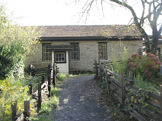
This campground on the west side of the Sacramento River was originally, literally, a garbage dump. About forty years ago the dump was filled, graded, and improved and in 1964 the area was opened as a park. Fishing, boating and summer swimming (if you can endure the icy cold water) are the primary activities here.

While there are pleasant walks to take, it's not really a "hiker's park" although some good hiking can be found at the nearby Sutter Buttes.

A one mile nature trail takes you along the riverbank lined by cottonwood and willow trees. The same wild grape-vines that seemed to be choking out all competing vegetation when we visited the area last summer, was still clinging to its hosts in its withered winter form. The trail is the old campground road. In 1980, the campground was moved to its present location to avoid the Sacramento River’s annual flooding. Large amounts of silt is left behind after the wet season, creating some of the richest farmland in the nation, and sometimes covering the boatramp and picnic area with mud. 


Almond and Olive orchards can be seen on an eastbound walk on the levee wall, but it is Rice that is currently the primary crop in the Colusa area.

Patty I and returned to the car at the campground and banged my camera around for a few minutes, hoping some harsh treatment might knock it into working order, but alas... so we headed to the nearby Colusa Casino for a quick lunch and consolation before exploring the southern end of the park. Only one of the casino's three restaurants was open, but it was satisfactory. This particular casino is still under construction. That, combined with an impoverished looking clientele gave it an aura of seediness and sadness.


The campground is lovely and well maintained, A variety of trees mingle, and at least one tree was conducting an experiment with gravity. As with many parks, the day-use fee was collected on the honor system. Happily, the adjacent Colusa Levee Scenic City Park will be taking over the concession of this State Park, allowing it to remain open! Yes!

We strolled south on the old levee, through the city park and under the twin water towers. If you look out you can see some of the cities old Victorian homes. But if you look straight down off the levee, you can see the less affluent old downtown, with views of the backside of small trailer parks and old historic Chinese establishments.

An dilapited old but still opera-ting movie theatre offered a single title, "Hunger Games."

Water level markers along the levee bank indicate when evacuations are in order.

We turned around at the bridge on...Bridge Street! But, if you like you can continue walking south on the levee for a few miles, viewing the expansive agricultural lands. The current bridge was built in 1980. The original Colusa Bridge is a designated his-toric site. The turning mech-anism from the old truss bridge is on view at the park.

We walked through the old downtown on our way back to the state park. On this late Saturday afternoon businesses were closed, and except for a couple of saloons, it had a bit of ghost town feel to it. The locals informed us that the Rite-Aid in the "newer part of town" was our only shot at getting a new camera within 50 miles. They had exactly one digital camera for sale, no better than the little one I was already using. Patty graciously offered to let me borrow her camera for our next day's trip to Anderson Marsh, but I declined. Photographing is a major enjoyment for us both, and I decided I should make due with what I had. It turned out alright.

I hope to see you at the state parks.

Lucy


Tuesday, April 24, 2012

JACK LONDON STATE HISTORIC PARK: Trip #35 of 70

Since visiting Jack London State Historic Park last November, it continues to be at the top of my list of recom-mendations for others to visit. It is located in the town of Glen Ellen in the heart of the Napa/Sonoma wine country. My late autumn visit found the surrounding vineyards burst-ing with color, often leaving me stunned and breathless by their beauty.

It is easily the most versatile park that I have visited to date, offering hiking, history, a museum, architecture, agri-cultural experiments, and of course much about the com-plex, literary, Renaissance man himself, Jack London. A writer, photographer, farmer, rancher, socialist, humanist, racist and adventurer all roled into one, London is best known for his rugged novels such as Call of the Wild, White Fang and The Sea-Wolf. Before becoming the most successful and most wealthy writer of his time, he made a hard living putting in long hours in factories, mining for gold in Alaska, and as an oyster pirate in the San Francisco Bay, drawing his colorful rough and tumble characters from his own experiences.

London began purchasing land in the Sonoma Valley in 1905 on what he referred to as his "Beauty Ranch", until eventually he had 1350 acres. This was his home until his tragically early death at the age of forty in 1916. His second wife, Charmian, continued to live in their cottage until her death in 1955.

This modest cottage and small guest house are preserved with many of the original furnishings, including Jack's writing desk. The severe work ethic that he adhered to in his days as a impoverished laborer followed him into his writing craft. He did not believe in waiting for the muse. Rather, he sat and wrote on a daily basis for at least six hours. I found myself envious of his discipline.

From the cottage you can see vineyards, livestock pens and examples of agricultural experiments. A small cactus garden sits where he and Luther Burbank unsuccess-fully tried growing a new variety of spineless cactus to be used for cattle feed.

Another failed crop were the 80,000 Eucalyptus trees he imported from Australia. With California's population increasing, wood was in short supply for furniture and hous-ing. London hoped that these trees would finance some of his other experiments. Alas, they were only useful for firewood.


As charming as this cottage was, it was not the building where Jack and his wife had hoped to reside. The Wolf House, designed by architect Albert Farr of San Francisco, was to be their dream home.

Construction of this 15,000 square foot home began in 1910. A four story building with twenty-six rooms and nine fireplaces, it was built with local materials including volcanic rock from the nearby Valley of the Moon quarry, Mexican style tile made in Oakland and wooden beams from his own property.

It was nearly completed when it burned down in August 1913. Forensic experts have since concluded that the fire was started by spontaneous combustion. Jack vowed to rebuild it but was financially unable to.

A 3/4 mile walk through a damp, mushroom laden redwood forest brings you to the lake and dam that Jack created for crop irrigation. With the addition of a bath house and pier, the lake was used for fishing and swimming for 75 years. Today the lake is shallow and filled with silt. The dam wall is leaking. The Jack London Lake Alliance is fundraising for the restoration of the lake and dam and to preserve the water quality for local wildlife. Nonetheless, folks still enjoy walking along the top of the wall.


Perhaps the most entertaining structure at Beauty Ranch is Jack's infamous Pig Palace. London hoped that this circular, luxury accommodation would "make anyone who is interested in the manufacture of pork sit up and take notice."

Indeed they did, but not necessarily with any respect. It was a great amusement to other ranchers who thought London best stick with his novels and short stories.

Nearby stand two silos of hollow core concrete blocks, the first of their kind as London continued his dream of the perfect farm. They stored green silage from corn stalks, which was fed to the cows, while the pigs ate the harvested corn.

A third and final building was built by Jack's wife Charmian.  The museum - "The House of Happy Walls," is a two story stone structure built in a redwood grove as a memorial to her husband’s life and work. Displayed here are many of the artifacts the London's collected on their world travels abroad while circumnavigating the globe on their yacht, The Snark.


The voyage that was intended to last seven years saw the Snark sail to Hawaii, the Marquesas Islands, Tahiti, the Solomon's and ended on the Island of Guadacanal. Ill health and ill fated problems for The Snark ended yet another adventure.

Jack London was found dead one morning of unknown causes in his cottage at the age of forty. Forty! Given that the first half of his life was filled with poverty and hard labor, I found the quantity of his endeavors amazing. It made me briefly wonder what I'd done with my own time.

 As Jack wished, his ashes, and later those of his wife, were spread near the grave of some pioneer children who had been buried on the property decades before. The day I visited happened to be the anniversary of his death, and a small ceremony that included readings of some of his work was being held at the gravesite.

The Jack London SHP was established in 1960 in accordance with the wishes of his wife. My money is on this park staying open. School children who visit often write letters to the Governor. I spoke with several individuals who were actively in the process of setting of cooperating organizations to keep the park open. So, I think next November I'll be making another trip here. While you can easily log four-five miles of walking just to see the sights I've described here, I think next time I'll to hike the 8-1/2 miles on Sonoma Mountain and view the turning vineyards from a higher vantage point.

I hope to see you at the state parks.

Lucy


Friday, April 13, 2012

SAN PASQUAL BATTLEFIELD STATE HISTORIC PARK: Trip #34 of 70

The noble tree is no doubt, used to her influential role during the world's most pivotal moments. Be it Buddha's Bodhi Tree, Eve's Tree of Knowledge of Good and Evil, George Washington's Cherry Tree or Boston's Liberty Tree where pre-American Revo-lutionary sentiment was nur-tured, the tree takes her place in religion, history and myth.

And so it was that this raggedy Pine Tree offered up her shade to planners of the Battle of San Pasqual, the bloodiest and most controversial battle of the Mexican-American War.


San Pasqual Battlefield State Historic Park in Escondido, (literally right around the corner form the San Diego Zoo Safari Park,) honors the soldiers who fought in the battle between the U.S. and Californio (Mexican) forces on December 6, 1846. Generals Stephen Kearny and Andres Pico both claimed victory.

Although the battle was only one of the war's military encounters, it proved to be the most costly in terms of human life, and the most disputed as to the outcome. The museum and adjacent battlefield have been set aside as a reminder of the human ideals, actions and passions that can drive nations to bloodshed.

The small museum is an easy but informative thirty minute walk through for the casual tourist. For those who are interested in the specific battle movements as they are re-enactmented from time to time at the park, there are very detailed "play by play" docu-ments. I will admit that I've often scratched my head as to why some folks are drawn to war re-enactments. As I flipped through a few of the pages, I found I was at least able to identify with it from the standpoint of a puzzle, a chess match, or even stage directions . Beyond that, I guess it's something I will never completely "get."

For the most part, the museum tells the history of not only the Battle of San Pasqual, but of the entire area going back thousands of years when the ancestors of the Kumeyaay Indians were the only inhabitants of the region.

What I especially enjoyed about this museum was that it pulled together the many snippets of history that are sometimes presented in isolation at other historic sites around the state.

The history is told on large story boards, well lit and easy to read in both English y Espanol. Each segment is beautifully illustrated by a drawing, painting, stained glass or costumed mannequin.

Beginning with the story of the indi-genous popula-tion, it continues through Spanish acquisition, the building of the Spanish Missions, Mexican indepen-dence from Spain, Mexico's secu-larization of the state and finally the Mexican American War when the United States acquired California.

A ten minute film about President Polk's War was available for viewing by request. The film focused on the political climate of the country and the controversy surrounding the acquisition of western lands. President Polk was an advocate of Manifest Destiny and aggressively went after new territories, but by no means did he have the support of the entire country.

Outside of the museum is a one mile nature trail, dogs allowed! The hike along the hillside had numbered sign-posts describing various plant and rock life, and panoramic views of the battlefield. A small amphitheatre hosts occasional multi-cultural concerts, recitals and lectures.

As I have mentioned before, Roxy is a dog I fostered through an organization called Guardian Angels for Soldiers Pets, taking care of dogs and cats belonging to deployed military personnel. She is a "navy brat" from the San Diego area. I wondered if she knew that she was only moments away from her southern California home.

Back inside the museum, a smaller desktop story board detailed the day by day gains and losses of the five day battle. There is way to much information to get into here, so if you want to know those details I guess you'll just have to visit the museum which is still open on weekends until July 1. I hope to take friends there before closure, combining it with a trip to the Wildlife Park and Stone Brewery!

In the end, the Battle of San Pasqual was the bloodiest battle of the Mexican Ameri-can War. Arguments will con-tinue to infinity with both sides claiming victory. Yet, it was a battle fought for reasons not clearly defined. Both sides made costly blunders and neither side gained significant advantage. The overall war continued unchanged by San Pasqual’s losses. So, while the museum presents a clear picture of the battle, the same clarity cannot be found within the battle itself.

As I drove away I saw a large animal in the battlefield. An escapee from the wildlife park perhaps? Ah,no. Tis a Coyote. It seems that the Trickster gets the last word on this trip. I wonder if that's who planted the Pine Tree.

I hope to see you at the state parks.

Lucy